Raffle
You probably remember the raffle that I promised. Well, we have five winners as follows
1. Bill McGregor - Roswell, GA.
2. Joyce Piatt - Mableton, GA.
3. Frank Jakse - St. Louis, MO.
4. Senthil Mukunthan - Indianapolis, IN.
5. Push Venkat - Chicago, IL.
Congratulations! Bill gets to pick any one of the five prizes. Joyce gets to pick any of the four prizes not picked by Bill and so on. Please scroll to the bottom of this page for a list of the prizes.
Errata:
On 6/3, I wrote from the Grand Canyon to say I had completed my hike. I incorrectly stated that we covered 13 miles in 10.5 hours. We actually covered only 6.5 miles in 10.5 hours. What can I say, it sure felt like we covered 13 miles.
Hike, Run, Cycle:
A couple of weeks back, I wrote to you all about upcoming LLS events and asked that you each consider participating and raising funds for this cause. I am happy to report that Senthiru Lakhi of Houston, TX responded saying she is going to run a half marathon. Go Senthiru!
I know there are more of you out there who can do this. Just Do It. for more info, please visit http://hikefordiscovery.org or http://teamintraining.org
Thank You:
I have enjoyed writing these weekly notes for the past 4 months. Thank You for supporting my hike, the Leukemia and Lymphoma society and for allowing me to clutter your in-box. Please let me know if you miss these notes and I can always start another fund-raiser :-)
Monday, June 11, 2007
Sunday, June 10, 2007
Grand Canyon Experience
Dreamland:
The alarm rang at 3:15 AM. I woke up and did not need to hit the snooze. I barely slept actually. I switched of the TV at about 9:30 the night before and slept. I was awake at about 11:30 though and couldn't go to sleep. I was far too excited about the next day. At some point, I dozed off. I dreamed that I was boarding the bus to the canyon along with the team. I knew it was a dream when I saw captain Jerry since I knew he didn't make it to GC. It was 2:15 and I went back to sleep rather quickly. The last hour was when I slept best.
I was ready pretty quick. I called David to make sure he was up and then headed down to the cafe shortly after 3:30. Judy and Ashley wished me luck and went back to sleep (at least Judy did). I wished Judy a happy Birthday before I left.
We collected our lunch sandwich and got a continental breakfast. We also got to meet our guides, Travis and Brian. Travis is actually from Marietta, GA and was very familiar with the places we had hiked as part of our training. He now lives in Flagstaff. Brian is a Ph.D. in Geology and teaches at ASU. He gave us a lot of info about the canyon. So much so, we named him "Doc Rock".
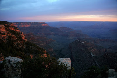
Sunrise:
We trudged out to the bus at about 4:30 AM. We had expected the temperature to be low and I was wearing a light jacket. There was another group also on the bus with us. They were going to hike the South Kaibab trail. I was seated next to Dave and as we were riding the bus, he was trying to get some last minute fund-raising emails sent using his Treo. Unfortunately, there was no cell-service inside the park and he couldn't get that done. We could already see the skies lightening up and it was a 11 mile ride to the Grandview point. There were a few points where we drove right by the canyon and I was able to take my first glimpses of the Grand Canyon. The enormity of the canyon suddenly dawned on me.
We got to the parking lot in time to see the sun come out. It was truly spectacular. The team spent quite some time taking pictures. We saw the Colorado river far in the distance. Superlatives such as "spectacular", "awesome" and "beautiful" were being liberally thrown around. We watched the sun come up over the North Rim and we could see the canyon change with the increasing light.
After some last minute instructions from the guides, it was off to Horseshoe Mesa. It was not at all cold and so the jacket was packed into the backpack and I started the hike with just a tee-shirt.
Horseshoe Mesa:
The hike down was at a relaxed pace affording plenty of opportunities for photographs. Brian kept giving us lessons on the Kaibab layer, Coconino Sandstone, etc. I enjoyed this aspect of the hike. I guess it is not very often that you have a Ph.D. in Geology take you on a tour of a geologic marvel such as the Grand Canyon. I have since found some pretty informative sites online about the geology of the canyon. Check it out.
On the way down, we stopped at Coconino Saddle for snacks and bio-breaks. Past the saddle, we saw several century plants(agave) in bloom. We also saw abandoned copper mines and mining equipment. The hike was at a very relaxed pace and we took another break at the old cookhouse when we reached the Horseshoe Mesa. There was supposedly a "toilet" here, but according to some of the hikers, it was best not visited - if you know what I mean.
After a short break, we continued along the western rim of the mesa. We had a brief part of the trail where the trail got real narrow with drop-offs on both sides. halfway through the section, Doc Rock turns around and says, "I guess I should have asked if anyone is afraid of heights". sense of humor indeed. Well, we did make it past and got to the very end of the horseshoe mesa with a good view of the valley below. We saw the Colorado river and it was a lot closer than when we had seen from the Grandview point, but it was still pretty far away. It was about 10:00 AM and we broke out the sandwiches.
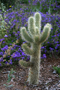
On Horseshoe mesa, we saw two different types of cactii and they were all blooming. There were a lot of bugs and many intent on taking up residence in my ear. dealing with them was the toughest part of the hike yet.
The descent was steep and rugged at times but it didn't seem to be as hard as the Coosa backcountry trail that we negotiated twice as part of our training.
Exploring Caves:
Brian told us about these caves on the sides of horseshoe mesa that we could visit since we were doing okay on time. Getting to the cave involved going off the trail and descending about 75 feet along a very narrow trail on the side of the mesa. Brian had a few flashlights and about half of us went into the cave first.
Apparently these caves were under water and were formed about 300 Million years ago. They run for hundreds of miles and are a constant 76 degrees year round. We really cooled off in there. We kept going deeper into the cave and there were a couple of places where we had to be on hands and knees going from one room to the other.
There was one place where we had to descend about 15 feet from one room to another. We got to this place where visitors from the past had left their signatures. There was P.D. Berry from 1897, Miles Brothers from 1906 and many more. Brian apparently left a record of our visit as well although he wouldn't tell us of the name he used or where in the cave he left it. Oh well. We got to one room and had to do what every cave explorer apparently does - turn off all our lights and see how far into the distance we could see. I could not see my fingers when they were an inch from my eyes. No amount of time was helping our eyes get used to the lack of light. freaky.
By this time, the fine dust on the floor was all over and we were breathing in liberal quantities of it. It was time to head out and let the second group smell the dust.
The sun comes out:
The second group was in there for about a half-hour or so and we headed out at about 12:30PM. The sun broke out of the clouds and we could feel the temperature going up. Doc Rock stopped us just after we got off Horseshoe mesa to point out the parts of the canyon where the stratification was along inclined lines rather than along horizontal lines. He mentioned these this was due to a fold in the crust caused by Tectonic action over the millenia and that that particular fold extends all the way into Utah. He pointed out a particularly large butte that was inclined and this particular formation was called the "Sinking Battleship" for it's shape and the angle at which it lay.
As we continued on the hike up, I started to get tired rather quickly and was dragging my feet. I had been eating my Clif bars and drinking my protein drink regularly. I also had an electrolyte drink called HEED of which I had consumed almost all of the 20 ounces that I carried. I had also been snacking on pretzels for the salt. So I was a bit confused when I felt the sharp twinge in my right heel at about 1:30 PM. I tried to continue on but the twinges kept coming and I took a big step above this one particular rock and my right calf and left wrist were now cramping. I could not grip my hiking poles.
I took a seat on a rock and popped an Endurolytes capsule. Rita Grayson also gave me a Crystal Light powder of which I took two packets, mixed in about 16 ounces of water and drank that in almost a single gulp. Sandy suggested I take one more Endurolytes capsule and stick to a dosage of two every hour. She also had me do a few stretches. They all worked and I was starting to feel much better very soon and started the hike back. We had just started on the part of the trail with the switchbacks and so I took it pretty slow since I wasn't sure how well I had recovered.
We reached the Coconino Saddle at about 2:30 PM. I checked my water reserves and I had slightly less than a quarter of my Camelbak left. Several others had already run out of the 120 Ounces and others were close to running out. Luckily for us, Sandy carried a ton of extra water and Travis had been walking around with a 2.5 liter bottle of water in his pack for just such an eventuality. After a 15 minute break, We headed back up.
Hey, there's a rattlesnake:
At 3 PM, I popped two more Endurolytes and continued up. At this point, I felt well enough to get back to trying to take pictures. I realized that the fine dust from the cave had settled on all the glass surfaces of the camera and had gotten caked and I couldn't seem to just wipe it off. All the pictures since the cave appear softened because of this problem and I didn't take too many pictures.
I did have to take one picture of the rattlesnake though. Doc Rock had to call mission control to have a bus sent for us and so he decided to go off trail so he could make a clearer call using his Satellite phone. he promised great views and a few hikers followed him. Scott Powell followed the hikers but chose to wait in the shade under a tree. He pointed casually to the rock over which him and all the others stepped over and said - "hey, there's a rattlesnake".
There was indeed a pink rattlesnake all coiled with his head under his body. We made enough of a commotion that he peeked out but seemed to go right back to sleep. Scot made his way back over the boulder and waited for the others to return so he could photograph them as they made their way back around the snake. The picture he took of Sandy was priceless. Well everyone made it back without incident. We also learned that the bus was already waiting for us at the parking lot.
Ice Cold Water:
As we hiked up, we started seeing tourists who were just taking the view from under the rim and getting a taste of the trail. Someone in our group said "Civilians.... that must mean we are close to the end.." We were indeed very close to the trailhead and completed the hike shortly before 4 PM. I took two more Endurolyte capsules and just stood gazing out at the canyon. I noticed Horseshoe mesa down below and even the cave we explored.
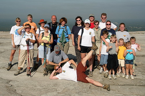
The place was teeming with tourists and one of them asked me how long it took for us to get to the river and back. "I don't know ..." I said, "we never got to the river ". In any case, we took some group pictures and headed to the bus. Our driver was handing out cold water bottles from a cooler. Oh, how sweet that water tasted. I sat in the very first row of the bus not wanting to walk anymore than I really had to.
Celebration:
We were going to meet at a bar at the bright Angel lodge for drinks, but it was almost 5PM when we reached the lodge. Judy and Ashley were waiting along with the Markert family - Dorothy, Dana and Delaney. They had seen the IMAX movie at the visitor center earlier in the day and walked 3 miles along the rim and then waited for us to show up. It was Judy's birthday and she even got a free admission to the IMAX.
We boarded a park shuttle to where Dorothy had parked the car. On the way, we saw two huge elk that were sporting massive sets of antlers. We got back to the hotel and had just enough time for all of us to get a shower and head down to Dinner.
Dinner was a south-western affair, with tacos, ground beef, fish, chicken, etc. I loaded up on coffee, proteins and cheesecake. After dinner, it was time to dance and Ashley had fun doing the Chicken Dance and the Macarena among others. Some of the hikers from other teams seemed to be having fun and provided plenty of entertainment for us. We did not stay long. Most everyone headed back around 8:30PM. It had been a long long day, but one that I will definitely remember for a while.
Encore:
We made plans to go out to Grandview point the following morning so Judy, Ashley and the Markert family could see the sunrise. The plan was to meet at the Lobby at 4:30AM. I woke up at 4 and found a note under our door from Dave saying they won't be making it. They were going to sleep in so they could go back later in the day and hike a bit. I met Katie, Sarah and Scot in the lobby waiting for their 5AM departure to Phoenix.
Judy, Ashley and I reached Grandview point at about 5:30PM. It was a bit chilly and Ashley was wearing my huge yellow jacket. We watched the sun come up and I showed them Horseshoe mesa, the cave and the approximate route of the trail. We also got to take a few steps into the trail before they headed back to the warmth of the car. I stayed a little longer, went a little further and reflected on the previous day.
We headed back to Tusayan after stopping at the park entrance for pictures at the National Park sign. We got a good breakfast at McDonald's and I crashed for a couple of hours since I knew I would be driving most of the way to Las Vegas.
I think, we all had a great time at the Grand Canyon. It was every bit as advertised and is an experience not to be missed.
Photos:
Saturday, June 9, 2007
Prologue
Westward:
After months of anticipation, it was finally time to head out to Arizona. We were all excited. Ashley was excited because she got to fly (among other things I guess). As usual, I was up late the previous night wrapping up stuff and barely got to sleep before we had to wake up at 4:30AM. We got to Phoenix on Thursday 5/31 and rented a car and drove to the Embassy Suites. We traveled separate from the team. We met the Abhazis on the flight. The trip was uneventful. Unfortunately, the team didn't have such a smooth flight. Thanks to Airtran, some were left in the check-in line, others were left in wrong gates. Everyone made it to Phoenix sometime during the day.
Phoenix:
We spent the afternoon indoors (away from the 105 degree heat). Judy and Ashley went to the pool for a very brief time. They beat a hasty retreat when they realized the heat (dry or otherwise) was unbearable. We visited the Desert Botanical Garden and were there from 6 till about 8PM. This park was quite neat. It was small enough to be covered in 2 hours but was packed with all kinds of native and non-native cactii. The plants were also blooming this time of the year. We got back to Scottsdale and drove by Frank Lloyd Wright's Taliesin West. We wanted to visit the place, but didn't think the entry fee for Ashley would be justified... We had dinner at a chinese buffet on Cactus Blvd near the Embassy Suites. The best thing that can be said about that is that the food was served with no delay.
We were all still on Eastern Time and so were pretty beat. So it was off to bed. I noticed the nice golf course and the hills just south of where we were and thought the sunrise would be pretty cool to capture and so set the alarm for 5:30 AM and slept. I woke up at 5:15 when I realized the room was already pretty bright. Apparently, the sun rises pretty early out here.. explain that to me. There were already folks out on the driving range and a queue was forming on the first hole waiting for the sprinklers to finish.
The plan was for the team to meet at the lobby after breakfast and head out at 9AM. We loaded the car and headed to breakfast at Tatum's and there was a long line since pancakes, eggs, etc were being cooked to order. After the dinner the previous night, I did not mind the wait for a good breakfast and it was good. I met the other hikers at breakfast. Most importantly, I met Sandy and confirmed that she did have my hiking poles. Since they were a bit unwieldy, she carried all our hiking poles - there's a leader for you. I noticed there was an REI just opposite the hotel and I guess I could have bought a pair if mine had been misplaced. In fact, there were some hikers who went over for last minute stuff.
Sedona:
The plan was to stop in Sedona at about 10:30AM and spend till 1PM when we would head out to the Grand Canyon. I followed the two buses for a while, but they were going too slow through the mountains so I figured I would pass them and let them catch up as we got closer to Sedona. We never saw the buses until we got to the Grand Canyon. We got off the highway and drove to Sedona, via Cottonwood, AZ. My decision to leave the highway and take the back roads was rewarded by a Starbucks at the exit :-)
The terrain in Phoenix was stark, drab and brown. I know some people love it. Seeing Phoenix, we realized how much we love the greenery in the eastern US. The scenery got better as we headed north. We took a detour through the main street in Cottonwood, AZ and then headed out to Sedona.
Sedona had these neat Red Rock formations. We stopped at the Red Rock State Park, took pictures around the visitor center and then it was on to the downtown area. We drove around looking for good locations to take pictures. We got a bite to eat at the Burger King (yeah, I know it doesn't sound very exotic) and then drove to the Coffee Pot rock. The rock formations all had names. Coffee Pot rock, Sphinx Rock, Capital Butte, Chimney rock, etc to name a few.
We spent about an hour taking pictures from a couple of spots, did some shopping at the Safeway and headed north on 89A to Flagstaff. On the way we made more stops at the Midgely bridge and at a spot in the Coconino National forest to look at the Oak Creek Canyon. These were all dramatic and it seemed to slowly raise our expectations of what we would encounter at the Grand Canyon.
We reached our hotel in Tusayan at around 5PM. This was just outside the entrance to the Grand Canyon National Park and the team had arrived earlier and visited the park. For several hikers, it was their first view of the canyon. As for me, the first view had to wait until the next morning.
Inspiration Dinner:
A temporary archway made of hiking poles greeted us as we entered the Canyon Star restaurant at the Grand Hotel. We had a buffet that featured lots of pasta. Hikers who had raised over 10K were recognized. The GA team had two hikers namely Cathy Lewandowski and David Markert who had raised over 10K. David in fact had at that point raised slightly over 20K. We also recognized all the LLS staff, the mentors and the hike leaders who have been crucial to our journey these past few months. The last group of people to be recognized were cancer survivors who were now hikers doing their part to beat cancer. The Georgia team had two survivors as well - The husband and wife of Anne & Ed Abhazi. There was no more doubt as to why we were there.
After Dinner, there was a dance presentation by members of the Navajo tribe. The GA team met briefly to go over departure times, etc and then gathered for a group photograph.
I had earlier been told that I would have to report for breakfast at 3:45 AM and that my group would have 13 hikers - 11 from GA and 2 from Columbus, OH. We left for our rooms at about 8:30PM. Judy and Ashley crashed almost immediately. I packed my Camelbak, made sure everything I needed for the morning was readily available and settled in with the Gladiator playing on TV. The last thing I remember before sleeping was "My name is Maximus Decimus Meridius, Commander of the Armies of the North, General of the Felix Legions, loyal servant to the true emperor, Marcus Aurelius. Father to a murdered son, husband to a murdered wife. And I will have my vengeance, in this life or the next." I was very sleepy, but I didn't sleep for long.....
Photos:
Sunday, June 3, 2007
I made it
I wanted to drop a quick note to say that I did make it out of the canyon. We hiked a total of 6.5 miles on the Grandview Trail to Horseshoe Mesa and back in about 10.5 hours. We descended some 2,700 feet. The weather was great. The sun was behind the clouds except for a brief period which made me dread what it would be like if the sun had been beating down on us all day (more on that later).
It was a great experience and I was glad I did it. More details and pictures will be in a later post :-) right now, it is off to Vegas.
It was a great experience and I was glad I did it. More details and pictures will be in a later post :-) right now, it is off to Vegas.
Tuesday, May 29, 2007
A shot of inspiration
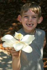
We started our training on February 10th with a hike up Stone Mountain. Several hikers had returned for mid-week hikes to Stone Mountain. This past Saturday, we returned for a group hike to close out the training. It was a relaxed walk up to the top. We had several guests who joined us. The kids were a lot of fun and the ease with which they were running up and down the trail was enviable. One of the kids was also a survivor. Caleb Kight was diagnosed with Neuroblastoma when he was 18 months sold. He underwent successful treatment and has been in remission for 6 years. It was great seeing him have fun. Here's Caleb with a magnolia he found....
More pictures from Stone Mountain are here.
Last week we all received a note from our honored hero Elijah Cox. I wrote about Elijah back in March. Here is Elijah's note.
Elijah Cox
5/15/07
Hike For The Fight
Thank you so much for letting me be the honored hero for the Hike for Discovery team. I know it's hard to train and do all the other things you have to do each day. Your time and energy you put into this cause... it means a lot to me and patients around the world. Hang in there during your walk and I will be praying for the team while you are there. Thanks for walking for me.
Sincerely,
Elijah Cox
It was pretty cool to receive this note. Speaking of Elijah, I learned last week that he is done with his once a month chemo regimen. He will have the port removed shortly and will be on maintenance for a while. Go Elijah.
Hike for Discovery:
... and so this hike will end on Saturday... but, the hike goes on for the millions of cancer patients. Atlanta LLS will be kicking of fall hikes to the Grand Canyon and Kauai, HI.
I hope you will consider joining this worthwhile cause. You can find more information about the GC and HI hikes at the Atlanta HFD site. The kickoff for these hikes is on June 9. Now is the time to step up.
If you do not live in the Atlanta area, you can find your local chapter at the HFD website - http://www.hikefordiscovery.org.
Perhaps you are a little more athletic and would like to run a marathon or complete a 100 mile bike ride, then Team in Training - http://www.teamintraining.org/ is for you.
regardless of whether you choose to Hike, Marathon or Ride, remember that no prior experience is needed. You will get professional training. A will to fight and make a difference is the only requirement. Hope you will consider this.
Tuesday, May 22, 2007
Counting to 10
This past Sunday, we headed back to Vogel State Park to hike the Coosa Backcountry Trail. We did this trail just the week before last and this was the last big hike before the trip to Arizona. The objective was simple.... finish the 12.5 miles faster than the 7 hours and 34 minutes it took last time.
The conditions were very different. It was a clear day with temperatures in the mid 40s as we started the hike. By the time we finished the hike, the temperatures had gone up to the mid 80s. The hike was just as hard as the last time. We made a lot fewer stops and I struggled to keep up with the lead group of 6 hikers. After a brief stop for lunch at the end of the first climb, We headed out without waiting for the rest of the group to catch up. It was that way the rest of the day.
We completed the hike in 6 hours and 30 minutes. The last climb up from Wolf Pen gap was where I struggled the most. That climb itself was very similar to the climb up to Kennesaw Mountain... not much of a challenge by itself, but it sure was hard after the first half of the hike. Maybe it was the heat, maybe it was the tripod that I was carrying... I had to force myself to take a 100 paces... counted 1 to 10 ten times, before I could stop for a 15 second break. Once we got to the top, we had to hike down that same brutal slope. I sure was glad Sandy chose not to hike in the clockwise direction.
Pictures from Coosa are here.
Fund Raising Update:
On 5/23, I will be turning in the last few checks and cash and calling this one done. Looks like the final tally will be $4,590.00 You guys are awesome.
We actually have a countdown meeting at the LLS office tomorrow evening. I will not be able to attend though. I will be at Turner Field watching the Braves beat the Mets along with a group of Atlanta area Vincentians. Go Braves!
Monday, May 14, 2007
Red-Eye Trail
This weekend we were going on a "short" hike and the plan was for Judy and Ashley to join as well. We were going to hike at the Sweetwater Creek State Park in Lithia Springs. I spent the latter half of last week in Redwood Shores, CA and if all had gone as planned, I would have had just enough time to get off the red-eye, go home, pick up Judy & Ashley and be at the park at 8AM. As it turned out, my flight was delayed and we got to the park only at 8:45 AM.
The group was long gone and it was up to us to make the best of the day. We chose to hike the Red trail. This trail was rated "moderate" and would take us along the creek to the "falls" overlook. It was only a mile to the falls from the parking lot, but it was a beautiful walk with the trail getting quite rugged at times. The rain overnight had caused the creek to swell up.
By the time we got to the falls overlook, Judy and Ashley had had enough. We decided to take the Blue trail back to the parking lot.
We had been to this park before for a picnic. We had no idea that there was such a beautiful hike (not that we had looked). Despite being a bit tired, Judy and Ashley enjoyed the hike. Next week, it is back to Vogel state park and the Coosa Backcountry trail. Two more hikes to go before the big one.
Pictures from the hike are here.
Fund Raising Update:
We did it. We have now met the goal. We are actually at $4,550 at this point. Words cannot express how happy I am at having met the goal. Thank You all.
Tuesday, May 8, 2007
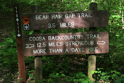
More than a days hike.

A few weeks back, I was responding to questions on our trail assessments and one of the questions was "Do you find it harder going up or going down? and Why?" My response was "Duh, of course going up is harder." After last week's hike, I wanted to change my response and say that going down is just as hard if not harder.
We hiked the Coosa Backcountry trail near Blairsville, GA. The trail was 12.5 miles and it was absolutely beautiful. The trail starts at the Vogel State Park and loops through the Chattahoochee national Forest. It has two peaks namely Coosa Bald and Slaughter Mountain. The group was rather small. Light rain was forecast and that might have kept some indoors. It was raining on and off all day. We started the hike at about 9:30AM. A smaller group of 4 chose to hike the shorter Bear Hair trail. We chose to do the trail in the counter-clockwise direction.
The trail was pretty easy to start with... a lot of flat and gradual climbs giving us plenty of time to warm up. Once, the climb to Coosa Bald started, it was relentless. About a quarter of the way in, one person "bonked" and had to be escorted back to the visitor center. About a third of the way in, one of the mentors fell and broke her wrist and started back along with one more person who had had enough.
The others trudged up Coosa Bald. Half way up Sandy and John figured that the elevation profile provided on the map was inverted and while it had the clockwise profile going left to right, it actually mentioned that it was the profile for our counter-clockwise hike. After that was cleared up, we were able to pace the rest of the hike. We climbed Coosa bald and descended to Wolf Pen gap where we stopped for lunch. The descent was the first indication of how hard this trail was going down. It was steep and rocky and quite slippery at places. Highway 180 crossed the trail at Wolf Pen gap and was the bail-out point if someone wanted to before climbing Slaughter mountain.
The half-hour rest was sorely needed. We started back on the trail and it felt like we had not had any break at all. As we started the hike, the camera refused to fire and needed a hard reboot (remove the battery and pop it back in). Given that and the constant drizzle, it had remained inside the backpack most of the time allowing me to stay at the head of our little group. After lunch though, I just had to get it out since there were some pretty cool features that I couldn't just walk by. Rita Grayson pointed out Pink Lady's Slipper - Cypripedium acaule of which I didn't know anything about until just earlier that morning when these plants were discussed on a garden show on radio. I thought it was pretty cool. Flame Azaleas and Large-flowered Trilliums were in bloom as well.
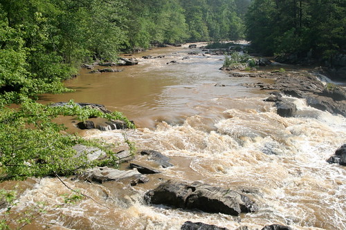
The hike down from Slaughter Mountain was long, steep and the hardest yet. My legs were literally burning and I had to stop to rest a couple of times! My legs were still sore on Monday morning. By the time we hit the last couple of miles of the trail, the rain had stopped and most of the hike was along the side of a stream. This included a couple of stream crossings over rocks, etc.. which provided some good photo ops.
We got to the trail-head at about 5PM. We had completed the trail in a time of 7 hours and 34 minutes. The trail lived up to the "Back-country" label. The trail was narrow and one person could barely fit in in many places. It was identified with yellow blazes throughout. At all the other trails, you could see that someone with a chain-saw had neatly cleared a path through fallen trees. Here, we simply had to climb over and walk around or under fallen trees. There were not too many hikers. We only saw two other hikers on the entire trail.
Some of us drove to Dahlonega and had dinner at Wylie's. It was "eighth grade dance night" and it looked like everyone in the square and the restaurant were dressed up. Everyone except us that is. The restaurant didn't throw us out and the food was pretty good.
I guess the one thing that will be definitely be harder than the climb down from Slaughter mountain is the climb up to Slaughter Mountain on the clockwise direction... When you hike the trail in the clockwise direction, you hit the climb without much of a warm-up. Knowing our fearless hike captain Sandy, I am sure that is exactly what we will be doing when we head back to Coosa on 5/20.
According to the state park, this trail is rated "strenuous" and they expect the average hiker to complete this in 9 hours.. although they strongly recommend doing the hike over two days. They had us all register at the visitor center and gave us enough warnings. At the fork where the Bear Hair Trail and Coosa Trails split, they had a sign that said "More than a days hike".
Pictures from Coosa are here.
Fund Raising Update:
As of today, We have only $30 to go. Thank You all. If you have been planning to but just haven't gotten around to doing it, I would greatly appreciate if you could do it now. Your donation is needed. I will be finalizing the paperwork, etc on 5/23. Can you believe that I have only 3 more hikes to go before the big one?
If I were President:
Ok, this has nothing to do with the hike, but I just had to share it... maybe you will get a chuckle out of it like I did. Ashley recently worked on a project about US presidents. One of the things she had to do was write a paragraph about what she would do if she were President. Here is her manifesto..
"If I were President, there won't be taxes. Also, there will only be two days of school. Monday is recess all day. Tuesday is water-squirting day. There will be a school pool. For dinner, people will have lollipops. I will live in Kansas. I will let animals run out of the zoo. People can jump on sofas."
Monday, April 30, 2007
The Lonely Planet

It was 9AM on Sunday and I was all alone in front of the visitor center at Kennesaw waiting to start my timed mile. Technically, I wasn't "all alone", there were plenty of people around... but there was no one I'd gotten accustomed to over the past few weeks.
We were supposed to hike Kennesaw on Saturday, but there was a March of Dimes walk planned for that day and the hike was moved to Stone Mountain. I could not go to Stone Mountain because I needed to be home rather quickly to help Judy get our home ready for an afternoon of grilling with friends. So, it was me by myself on Sunday morning. The objective was to see how fast I could cover the 1 mile to the top and to report the time to our Hike Leader.
As I set out, I swore I would never do this hiking by myself thing again. I got to the top in about 22 minutes. Not my best time, but not too shabby I guess. I had a lot of fun on the way back. I took my time (about 1.5 hours actually) walking back down. I noticed a lot of stuff which I had overlooked during past hikes. There were a whole new set of plants that were blooming this time around. By the time, I got back to the visitor center, I was beginning to think that I just might be doing more of these solo hikes. Pictures from Kennesaw are here.
Next week, we go to a new trail. We will be hiking at the Vogel State Park. It is going to be a long day on the trail.
Hike Update:
When we started the training, we were told that we could choose from one of several different trails. The trails were classified as Categories 1 through 4 with the descriptions stating that the Cat 4 trail should be attempted only by experienced hikers who have trained hard and who have hiked one of the other trails before. My aim was to train hard enough to attempt at least one of the cat 3 trails. Ultimately, it would be up to the Hike Leader to make the call as to what trail we will be hiking.
Well, Our Hike Leader and Captain had been encouraging a few of us to go for the Grandview trail (the only cat 4 trail) and so I opted for that and that is what I will be hiking. As with all the other trails, this one doesn't go to the river either. We travel about 3.2 miles in and descend 2600 feet to Horseshoe Mesa. The entire hike is expected to take about 8 hours.
Here is a very good account from another Georgian who hiked the Grandview trail last May.
Fund Raising Update:
April 30th is here and I had set a goal of reaching the target. We are very close indeed. We have so far raised $4,395.00 We need to raise only $105 to reach the goal.
Thank You very much. If you were planning to write a check but just didn't get around to it, We still need your help. The $4,500 is a goal but one that is by no means all that is needed. Every little bit is needed. If we can raise $25 more, then that is one extra prescription for a patient. A $100 more will cover the cost of 2 CT scans for patients.
Tuesday, April 24, 2007
T minus 315
Last weekend was spent driving rather than hiking. Judy, Ashley & I drove up to South Bend, IN on Friday with stopovers in Indianapolis, IN and Huntington, IN. We drove back on Monday. We had a good couple of days visiting with friends and family and attending my nephew's First Holy Communion mass.
In the meantime, you all kept the donations coming and we are now only $315 shy of the target. Thank You. If you have been meaning to, but just haven't gotten around to making that donation, now is a good time to do so :-)
This next Saturday, we are back at Kennesaw Mountain where we will be timed so our Hike Leader can evaluate us and validate our choice of trails - I have been told that this will be a mere formality if one has been attending all the group hikes.
Monday, April 16, 2007
The world is flat ...

... or so it seemed this past Saturday as we hiked in the Amicalola Falls State Park towards the Len Foote Hike Inn. There were enoughs ups and downs but after some of the recent gradients we hiked up, this one seemed flat. We met at the upper parking lot on top of the falls and were supposed to do a 6 hour loop with a stop at the Len Foote Hike Inn. Thunderstorms were forecast for the afternoon and so the hike was cut short to 4 hours. We hiked 5 miles from the parking lot to the Len Foote hike Inn with no stops. The one way trip was supposed to take 3 hours on average, but we made it in only 2 hours. Everyone was in super shape. I was at the head of the pack and stopped very briefly to snap a few pictures of the Dwarf Violet Iris - Iris verna and before I knew it, I was trailing the pack. The Irises were everywhere, so were Violets and various Yellow-violets.
We spent about a half-hour at the Inn and headed back at the same pace. We reached the parking lot and this time, I had to taste Dean's fine home-made brew even though I was driving. I assure you it was only a taste.
The thunderstorms never came. At least not until I got home. On the way back, we decided to stop at The Crowe's Nest restaurant in Jasper, GA. Apparently this place has great burgers and is some sort of a landmark. But, they were closed. It was Saturday afternoon so I don't know what that was about. We ended up at the "Savor" bar. A little family-owned restaurant serving Peruvian and American cuisine. the food was pretty good.... but the service was not rushed.
Next weekend, we are traveling to SouthBend, IN. and I will be missing the hike at The Benton McKay State Park.
More pictures of the Irises are here.
Fund Raising Update:
The end is in sight. We had set an Intermediate goal of reaching 75% - $3,375 by April 15th. As of April 16th, we have raised $3,835.00
We need to raise $665.00 to complete this fund-raiser. Thank You all for your support.
Website Update:
A few days back, I was looking at the analytics to see what kind of traffic I was getting on the website. As expected, most of the visitors were from The USA. I also had a substantial percentage from India. I was however surprised to see visitors from the following places.
Elwood & Sydney - Australia.
Beijing, Nanjing, Hsinchuang & Shandong - China.
Christchurch - New Zealand.
Partizánske - Slovakia.
Culleredo - Spain.
Ekefall & Karlstad - Sweden.
Rome - Italy.
Well, so far, all the donations have come from the USA and India. I definitely would not mind receiving a few Yuans and Euros :-)
Monday, April 9, 2007
29 F

After two weeks of perfect hiking weather, winter returned. Yes, it was cold ... even in the Metro Atlanta area. It was 29 degrees Fahrenheit when I left home Saturday morning. Our hike leader likes to alternate long and short hikes and this past weekend, it was time for the shorter hike at Kennesaw Mountain.
Given the cold weather and spring break, there were very few hikers (maybe around 12) in our group. It was cold enough for me to stay focussed on the hike rather than stopping to take pictures. There weren't many good ones in any case. The frost made the wildflowers look rather sad.
We got to Burnt Hickory road and back to the Visitor Center at about 11AM. The hike down from Big Kennesaw to the Visitor Center was the coldest. Even though the temperature had gone up to 36 degrees, the wind was blowing hard and it felt a lot cooler than that.
Next week, it is back to the Amicalola Falls State Park. This time we will go lot farther and up to the Len Foote Hike Inn.
Survivor Update:
Do you have a loved one who is currently fighting cancer or who battled cancer in the past? Please let me know if you would like to make a small memorial for them on my web page. After all, it isn't about campaigns, numbers or some such abstract idea. It is about real people who fight cancer everyday.
Fund Raising Update:
As of 4/9/07, We have raised 3,175.00 - We are 70% of the way there.
I still need to raise $200 to reach my next milestone of 75% by 4/15. Thank You all for the support and your generous donations.
ps - If you made a donation either on the website or by mailing me a check and if I have not sent you a personal Thank You note, please let me know. I recently heard that some website donations during the last year were incorrectly recorded and as a result the person raising the money was not credited for those donations and more importantly did not know of those donations. This was a glitch, but I want to make sure that no donations go unrecognized.
Power of your money:
- $1,000 - supports one week’s salary for a medical researcher at Emory who may discover key information to developing curative treatments for blood cancers.
- $500 - provides a patient with leukemia, lymphoma or myeloma with patient aid to support medical treatment and to travel to medical appointments for one year.
The past few weeks I have included a couple of points such as the ones above regarding how your donation can help in the fight against cancer. These came from a document published by the Leukemia and Lymphoma Society.
When we look at a problem such as cancer, it is easy to get discouraged about how big the problem is and what little we as individuals can do. I hope these few points helped convey the importance of what your contribution means to this fight. When we are done with this fund-raising, we will have bought 4.5 man weeks of additional research. The group as a whole will be raising $366,000. That is 7 years of research into cancer or 7 researchers for 1 whole year on cancer. Something good is definitely going to come out of that.
“Anything is possible. You can be told that you have a 90-percent chance or a 50-percent chance or a 1-percent chance, but you have to believe, and you have to fight.” - Lance Armstrong.
Monday, April 2, 2007
Sanguinaria canadensis

Last week, I posted a couple of pictures of wildflowers that I snapped during the hike at Kennesaw Mountain. My friend Suzy Gruenhagen of Dahlonega, GA. pointed out that the white flowers were called Bloodroot - Sanguinaria canadensis and the red flowers were called Fire Pink - Silene virginica. Well Suzy, I am happy to report that I found a lot more Bloodroot blooms this past weekend. I also found a few other wildflowers that I had fun trying to identify. I found Taraxacum officinale, Rhododendron catawbiense, Conopholis americana and Viola rotundifolia to name some. I also found an Actias luna on the hike back up Rocky Mountain. There are a few that I wasn't able to identify.. so, Suzy, I am looking for your input :-)
We went back to the Appalachian Trail. It was my turn to drive and we had the Sienna full from Canton. There were two groups again, one hiking for 4 hours and I was with the second group going up to Tray Mountain on a 6 hour hike. the weather was perfect (mid 50s). The ice that we saw on the slopes of Rocky Mountain were gone and there were plenty of wildfowers in their place. The hike up Rocky Mountain from Unicoi Gap was just as hard as the last time. We got down to Indian Grave Gap (where I turned back the last time) in about an hour and 15 minutes. After a brief stop, it was back on a long, steady climb over about 2.8 miles to Tray Mountain.
There were 15 of us and a dog and it felt like a crowd at the Summit. We started back after about 20 minutes at the top. The area close to the top was covered with Catawba Rhododendrons. These were still budding, but in trying to identify this plant, I saw pictures of the blooms and I can't wait to go back when they are in full bloom. Of course, I could be totally wrong about what plants these really are... :-(
We started the hike back and I snapped most of the pictures on the way back. After what seemed an eternity and another hike up from Indian Grave Gap to Rocky Mountain, we got to the trail head in 5 hours and 50 minutes. We had hiked 10.8 Miles, climbed 3,500 vertical feet and gone approximately 3.5 dots on the A.T. map. At the parking lot, Dean had home-brewed beer for the group. Of course, I had to drive.
More pictures from my day on the A.T. are here.
Rocky Mountain and Tray Mountain facts:
- The Rocky Mountain we climbed is one of 9 peaks in Georgia of the same name.
- At 4,430 feet, Tray Mountain is the seventh highest peak in Georgia. Rocky Mountain is number 27 on the same list. Tray Mountain is also the second highest peak on the Georgia section of the A.T.
- The climb up to Rocky Mountain took us from an elevation of 2,949 feet at Unicoi Gap to 4,017 feet at the Summit in about 1.3 miles. That is an average climb of 821.5 feet per mile. The most strenuous trail at the Grand Canyon has an elevation change of 2,600 feet over 3.2 miles. That is an average elevation change of only 812.5 feet per mile. I guess I am ready.
Hike Update:
Several of you have asked when exactly I will be hiking the GC. Well, the dates are in. The hike is on June 2nd. Judy and Ashley are also going to fly out with me. We will be leaving for Phoenix on May 31. After spending a night, we travel to our hotel near the canyon on Friday June 1st. After the hike, the team leaves for Phoenix and Atlanta on June 3rd. We are planning to spend June 3rd in the Sedona, AZ area and travel to Las Vegas with a stop at the Hoover Dam on June 4th. We will be leaving Las Vegas on the 5th to get to Phoenix in time to catch a red-eye back to Atlanta.
Are you planning a vacation? How about the Grand Canyon? Come on out and join me on my hike weekend.
Fund raising update:
As of March 31st, We have raised $2,700 Yes!
Next target is to hit the 75% mark - $3,375 by April 15th. We have to raise $675 to make that goal. Thank You everyone.
Power of your money:
As you consider a donation to this cause, consider what your donation can do...
- $ 500 - allows 10 patients to logon to a webcast and hear the latest information in treatment for their disease.
- $ 150 - allows 5 patients to make a First Connection with a trained peer volunteer.
Monday, March 26, 2007
To hike or not to hike ?

To hike or not to hike? That was the question I was faced with last Tuesday. You see, Tuesday was when I had to "re-commit" to this endeavor. "Re-committing" involved providing a credit card to LLS that they would charge in the event that I failed to raise $4,500.00 - LLS incurs a cost in going forward with the travel arrangements, etc and this ensures that I stay focussed on the training and fund-raising ( and don't bail at the last moment).
I had to pause for a moment to think this through given that I had raised only slightly over 25% last Tuesday. I am happy to report that I did indeed re-commit over two slices of Bella's Pizza and a Terrapin Pale Ale.
I am even happier to report that as of today, I have crossed the 50% mark. We have now raised $2,255.00 - Thank You all. The next target is the 75% mark of $3,375.00 by April 15th.
Speaking of April 15th, most of you are probably working on your taxes... I have to say you will feel a lot better next year this time if you donate to this cause... Apparently, research has proven that the good feeling generated is directly proportional to the amount of money you contribute :-) Ok, I made that up, but come on, we don't need research to prove that..... So, if you haven't already, go ahead and make an investment for the future.
Training Update:
We went back to Kennesaw Mountain last Saturday. The place has changed so much in the two weeks since we were there last. It was a beautiful day. No sweatshirts and/or jackets were required. It was dry and the day probably started out at 50F.
We made the Hike up and down Big Kennesaw and then up and down Little Kennesaw to Burnt Hickory. Our Hike leader and some of the mentors turned back mid way. They said they had to conserve energy because they were going to run a marathon the next day. Surely, you are nuts, was all I could think. In any case, we crossed Burnt Hickory road, hiked a little over a mile of rolling hills, and then climbed little Kennesaw and Big Kennesaw to get to the visitor center. The final climb was a pain just like it was two weeks ago. The sun was out and that didn't make it any easier. I did manage to get a few good spring pictures.
Next week, we head back to the Appalachian Trail. Our hike leader Sandy Geisel apparently liked the hike up Rocky Mountain so much that she has decided an encore is in order. This time, we will most likely go a lot farther than the Indian Grave Gap.
Power Of Your Money:
As you consider a donation to this cause, consider what your donation can do...
- $ 200 - provides a Family Support Group Program for one year.
- $ 100 - provides 3 patients access to an informational teleconference.
Monday, March 19, 2007
Dots on a map

This past Sunday, we were supposed to hike at the Unicoi State Park near Helen in NE Georgia. The hike was scheduled to start at 9AM rather than our usual 8AM.. which was just as well given the distance.
We met at "It's a Grind" coffee store in Canton, GA. The caravan included two cars and I drove with Sara, Scot & Cathy. We got to Unicoi at 9AM and we got checked in and Dean came up with the idea of driving 10 miles north and hiking the Appalachian Trail instead. After a quick show of hands, we got back in the car and headed North. The temperature was forecast to be 34F when we started, but driving to the parking lot, we saw a sign that said 29F and it definitely felt a lot cooler when we got out of the car.
We started the hike at Unicoi Gap at a height of 2975 feet and it seemed that the trail was straight up for about the first 30 minutes after that it was a gradual slope till we hit the summit of Rocky Mountain. We had climbed 1125 feet in 1.3 miles. We had some of the best views of the North Georgia mountains shortly after the summit as we were descending towards Indian Grave gap. The cold which was biting as we started up the hike was gone and there was little or no wind at the top. The descent was steep and it looked like the mountain kept falling off. Every step down made the hike back up just that much harder. We got to Indian Grave gap in a time of 1 hour and 19 minutes.
After a rest of about 15 minutes, fuel and water, I joined the group that was headed back to Unicoi gap. About half the group continued further on the trail to Tray gap. Their hike would have lasted 4.5 hours and I made the mistake of not packing lunch. I had enough fuel in the form of gels and bars.. but I wasn't sure if I could last long without something solid. The climb back up the mountain seemed steeper.
I clicked a few pictures and took it easy once we got to the top. The slope down was covered with ice formations that looked like millions of tiny silver threads strewn around. It looks like I may have figured out a way to rig the camera and use it comfortably while it stays attached to the backpack. We got to the parking lot, stretched, got in the car and headed to Helen in search of burgers. We stopped at Wendy's, got burgers, overheard this group of teenagers exchanging camping stories... clearly they had been smoking something illegal :-) and left for Canton.
In retrospect, I am glad I got to hike a portion of the A.T. I wish I had planned properly and gone on the longer hike.
You are wondering what the dots are about? Well, as we finished the hike, we saw a map of North Eastern Georgia with the A.T. marked by white dots. There was a label next to Unicoi gap that said "you are here". We also found Indian Grave gap where we had turned back. It was about 2.9 miles and a whole 2 dots from where we had started . so, there you have it.
Here's my album from the A.T.
Fund Raising Update:
We have set a target of reaching the 50% mark - $2,250 by March 31st. As of March 19th, We have now raised $1,400.00
Today, I got a check in the mail from someone I didn't know. A friend of mine had forwarded one of my email to his friends and voila! It was a great thrill. Thank You all for your donations and support and keep it coming.
Quote Of The Day:
"... it is not A canyon. It is not a big canyon. It is not even a large canyon. It is the GRAND canyon. Did you know that before you signed up to hike?"
-- Lou Horowitz expressing his concern on learning about what I had set out to do. Lou, Thanks for the concern and the donation.
Power Of Your Money:
As you consider a donation to this cause, consider what your donation can do...
- $ 75 - is the average cost of tissue typing to become a bone marrow donor.
- $ 50 - is the cost of a CT scan.
Tuesday, March 13, 2007
Kennesaw Mountain, GA.

The Kennesaw Mountain National Battlefield Park is 15 minutes from our home and we drive past and even through all the time, but had never actually spent much time at the park. That changed this past Saturday.
This was the longest hike that the group has embarked on this season. I actually got to wake up late (at 6:45 AM) and got to the park as usual at 8. We had a person from LLS come and explain the basics of leukemia and other blood cancers. We hiked up and over "big" Kennesaw and then up and over "little" Kennesaw to Burnt Hickory Road and then back up and over and up and over back to the Visitor center. We hiked a total of about 5 miles.
I got to test my trekking poles and they made a huge difference. Climbing was a lot less harder and descending was lot easier on my knees. The only problem was that, with two hands tied up, the camera had to stay in the backpack. I did not get too many pictures. There were some really neat features such as the natural rock garden and the cannons up "little" Kennesaw... will have to go back to get pictures. also, will have to figure out a way to rig the camera so it can be accessed easily. The few pictures I snapped are available here.
Fund Raising Update:
We set a target of reaching the 25% mark - $1,125 by March 15th. As of March 12th, We have already surpassed that goal. We have now raised $1,185 Yes!
Next target is to hit the 50% mark - %2,250 by March 31. Thank You everyone.
Elijah Update:
Last week, I wrote about our honored hero Elijah Cox who has been fighting leukemia. here is an update from his mom..
"He is currently on treatment. He takes daily chemo medication that I administer to him and then he goes in once a month for the liquid forms of chemo, have his port flushed and each 3rd month he has a spinal tap and that day is usually our longest day at the clinic. But God has been so good and Elijah is able to tolerate the medication without any problems.
He is due to come off treatment in May of this year. He has 1 spinal tap left. After May, he will be on maintenance and will go once a month to check his blood to make sure no cancer cells are present. He will do this for 1 year.
When he was first diagnosed and I was told that his treatment is for 3 years and 2 months, it seemed like forever. But, the years have gone by and I can’t believe that May is just around the corner. Thank You for your support and concern for Elijah. We really appreciate all that you do for all those with cancer past, present and future.
Ladonna."
Excerpt from an email sent to Karen at the LLS on March 7th, 2007.
Go Elijah!
Power of your money:
As you consider a donation to this cause, consider what your donation can do...
- $ 40 - Cost of sending a comprehensive packet of information for children with cancer.
- $ 35 - Pays for transportation expenses for a patient living in Northern California’s most rural areas to treatment at a comprehensive cancer center.
Monday, March 5, 2007
Elijah Cox

Cancer is here and now. This year, the Hike for Discovery team is training and raising funds in honor of Elijah Cox.
Elijah is 8 years old and was diagnosed with Acute Lymphocytic Leukemia in 2004. His birthday is on May 27th. His parents are Glenn and Ladonna, He also has a younger brother named Joshua.
Like most children, Elijah enjoys riding bikes, playing basketball, matchbox cars, video games, swimming and music. I have not had a chance to meet him yet, but apparently, Elijah is very friendly, likes to travel, is very active, loves the outdoors and has a very sweet disposition.
When you are eight and you can handle leukemia with a smile like Elijah has, you can handle anything that life may throw at you. Elijah is an inspiration.
Do you have a loved one or friend who is battling cancer now or battled in the past? I would like to hear from you and write about this person on this site. The idea is to bring a human face to the problem so everyone can understand that cancer is here and now.
Fund Raising Update:
We have blown past the 10% mark. We have raised $600.00 so far. Yes! Next target is to raise $1,125 by March 15th. With your help, I am sure we will blow past this one as well.
Power of your money:
As you consider a donation to this cause, consider what your donation can do...
- $25 - covers a single prescription co-payment.
- $5 - is the cost of sending a newly diagnosed patient packet which includes information about their specific disease and support.
Training Update:
This past weekend, the group was busy exercising at Piedmont Park under the instruction of Jerry. Not me. I was busy exercising restraint in Las Vegas. I am back training starting today though. I have one more planned weekend off on 4/21. With the exception of that, I promise no more slacking off until the hike.
Monday, February 26, 2007
Amicalola Falls State Park, GA.

Last weekend, the group hiked Kennesaw Mountain. I chose the magical confines of Disney's Animal Kingdom instead. This weekend it was back to real work.
Woke up at 5:30 AM and hitched a ride with 6 others to the Amicalola Falls State Park in Dahlonega. I didn't know these facts, but apparently Amicalola is the highest water falls in the US East of the Mississippi. It is also where the Appalachian trail starts. The 8.5 mile approach trail takes you to the southern end of the A.T. and from there it is 2,100 miles to Mt. Katahdin in Maine.
Well, we were definitely not going to hike that far.. not that day anyway. After a bit of excitement with a lost hike captain, the hike got underway. We went approximately 2.5 miles on the Appalachian Access Trail where we encountered several hikers who were obviously going a lot further than we were....
After, the hike, it was time for a little bit of socializing and home made granola bars. Thanks to mentor Jennifer Coffey. The ride back to Canton was mostly quiet.... there was that conversation as to whether Williamson Bros BBQ had the best pulled pork....
Back home, I ate lunch and crashed. I enjoyed the day. Some pictures are available here.
Fund Raising Update:
I finally got around to contacting people. Thanks for all the donations, pledges and the words of encouragement and support.
I do have a request. LLS is offering a $50 REI gift card for the person who collects the most money in online donations between 2/21 and 3/2. I would love to win this gift card. If I do, I promise, it will be one of the raffle prizes. So, there is no time like now to make that donation. Donate online at http://tinyurl.com/33qyrc . Thank You.
Web Site Update:
I have added a Live Chat window to this site. so stop on by often and say hello.
Sunday, February 11, 2007
Stone Mountain, GA.

I was parked at the St. Michaels and All Angels Episcopal church parking lot at 7:45 AM on Saturday. We were going to meet there and walk into the park so we wouldn't have to pay the $8 per car :-). Sitting in the car, I was quite warm and toasty and had no idea how cold it was outside.
We had been warned that the temp would be around 30 with a wind of 10-15mph. It was cold and I had to borrow a ski cap from Captain Jerry.
The hike itself was quite comfortable. I had not seen this side of the Stone Mountain in all my previous visits. We could see patches of ice on the slopes. Luckily for us, the mountain is so bald that the water doesn't puddle and freeze.
It was 1.25 miles to the top with a very brief section that was steep. It was cold and windy at the top so it was a quick turnaround. After the hike we went to REI for a gear clinic and ended up buying some stuff that we will need.
The day's activities could perhaps be captured by this credit card ad...
REI Hiking Boots: $90
SuperFeet Insoles: $35
Hiking Socks: $10
LEKI Trekking Poles: $65
Camelbak Hydration System: $90
Being able to sleep in on Saturday: $4500
Helping find a cure for Cancer: Priceless
here are some more pictures from my day at Stone Mountain.
Monday, February 5, 2007
Kick-Off
The fund-raising and training are now officially on. We have a published training schedule for the next 3 months. This includes individual as well as group training sessions with the first group hike scheduled for 2/10 at the Stone Mountain.
I also have a mentor - Carol Dierdorff aka Hiker Babe has promised to whip me into shape :-)
I also have a mentor - Carol Dierdorff aka Hiker Babe has promised to whip me into shape :-)
Thursday, January 25, 2007
The Starting Line
Judy and I visited the LLS offices on January 20th, listened to the volunteers chart out the process and had a serious panic attack when I found out that I would have to raise $4500 before June.
Seemed like a large amount to raise especially given that I haven't done any serious fund-raising in the past :-) The enthusiasm with which everyone else was signing up was contagious... and Judy provided a firm push. The forms were signed and I am in.
The next step is to attend the Kick-Off event on February 3rd.
Subscribe to:
Posts (Atom)
Raffle
Every donor was entered into a raffle with one entry for every $10 donated. There are five prizes that can be one. Each donor can win no more than one prize. The first winner gets to choose any one of the five prizes, The second winner gets to choose any one of the remaining four and so on and so forth.
| 1. | 
|
Flora
24" x 24" poster. all photographs by Albert Thomas. See larger image. |
| 2. | 
|
Sun and Water
24" x 24" poster. all photographs by Albert Thomas. See larger image. |
| 3. | Super Bowl I - XXX
A football lovers dream. Collectors set of DVDs of all the Superbowls from I to XXX by NFL films. |
|
| 4. | TaylorMade Golf Balls
A dozen TaylorMade Distance Plus golf balls. According to TaylorMade, these balls are "built to maximize distance and improve scoring for the committed player". |
|
| 5. | Maxfli Golf Balls
A dozen Maxfli Noodle Golf Balls. |
|
... and the winners are
- Bill McGregor - Roswell, GA.
- Joyce Piatt - Mableton, GA.
- Frank Jakse - St. Louis, MO.
- Senthil Mukunthan - Indianapolis, IN.
- Push Venkat - Chicago, IL.
Options to spend money and feel good about it..
| Help bridge the chasm by purchasing one or more of the following unique services. Some of these have a material cost component. This will not count as a tax-deductible contribution. Please send me an email if you would like to commission one of the following. Thank You. | |
| 1. Scan and Create Web Album from photos – 75 Photos. | |
|
|
Got a lot of pictures from your pre-digital days? I will scan those and create a slideshow CD. If needed, I can also upload them online and create a web album for you. I can scan up to 75 pictures. If you have more ( I hope you do), please see the next item. Sponsorship Amount: $75 (entire amount is tax-deductible) Material Cost: $0 |
| 2. Scan and Create Web Album from photos – 150 Photos. | |
|
|
Got a lot of pictures from your pre-digital days? I will scan those and create a slideshow CD. If needed, I can also upload them online and create a web album for you. I can scan up to 150 pictures. Sponsorship Amount: $100 (entire amount is tax-deductible) Material Cost: $0 |
| 3. Your own Photo Poster. | |
|
|
How about a photo mosaic of your favorite pictures and/or your favorite people. This will make a great gift for all those times when you have no clue what to buy (Hint: Mother’s Day is 5/13/07 and Father’s Day is 6/17/07).
Sponsorship Amount: $100 Material Cost: $30 (24” x 24” poster) |
| 4. Painted Wall Mural. | |
|
|
Planning a birthday party? How about a set for the party? The mural will be painted on poster paper and affixed to the wall using push pins so you can remove after the event. No need to repaint.
|
| 5. Mondrian Coffee Table. | |
|
|
So what does a $500 coffee table look like? Like the dining table pictured here. This is a one of a kind, contemporary coffee table that is also a piece of art. The coffee table is hand-crafted and consists of a Piet Mondrian reproduction using acrylic on canvas, framed by wood with a metallic finish. I don’t have a picture of the coffee table itself, because it hasn’t been made yet. Click here for a larger photo of the dining table. Coffee table will be 48” x 36”. Sponsorship Amount: $500 Material Cost: $100 |
| 6. Warhol at the Georgia Aquarium – Poster. | |
|
|
Warhol never visited the Georgia Aquarium. What if he had? What if he had seen the anemones at the Cold Water Quest? The poster was created using a photo I took of the anemones recently.
|


